Pre-Planning Farm/Ranch Emergencies
Agriculture is one of the most dangerous industries in the United States and Canada. Further, the unique hazards present on agricultural operations can pose challenges to firefighters and EMS personnel responding to on-farm or on-ranch emergencies. As a result, it is very advantageous for first responders to pre-plan agricultural operations and become familiar with the farms in their service areas. Potential benefits of pre-planning include protection of fire/EMS personnel from otherwise unforeseen risks, improved resource allocation and coordination of response efforts, and more efficient response times.
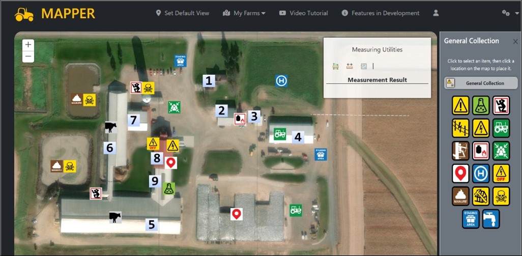
Farm Mapping to Assist, Protect and Prepare Emergency Responders (Farm MAPPER) is a free, interactive, data secure, and device-agnostic web-based tool developed by the National Farm Medicine Center (NFMC) to assist first responders with pre-planning farms and ranches. The goal of Farm MAPPER is to make responding to farm emergencies safer by providing first responders with onsite information about the hazards, resources, and physical layouts of agricultural operations. Access to this information when responding to an on-farm incident has the potential to decrease emergency response times, improve responder safety, expedite victim rescue, enhance structure protection, and facilitate rapid access to relevant resources.
New Version of Farm MAPPER
The tool was first developed in 2012 by NFMC researchers in collaboration with the Pittsville, Wisconsin Fire Company but has since undergone many updates to improve data security, user experience, and tool function. Since its original development, Farm MAPPER has become a central part of Rural Firefighters Delivering Agriculture Safety and Health (RF-DASH), a program that aims to equip rural emergency responders with farm-specific first aid curriculum, safety consultation capabilities, preplanning tools, and farm hazard assessment strategies to assist in emergency responses and prevent injuries and fatalities on farms and ranches.
Farm MAPPER utilizes custom-developed icons to clearly label hazards and resources relevant to agricultural emergencies. First responders (and farmers) can map farms in Farm MAPPER by dragging and dropping the icons onto an aerial image of a farm. After the user drops icons onto their farm map, the information can be accessed by emergency responders at the fire station or en route by smartphone/tablet. Farm maps can also be printed for use in areas with poor connectivity. Using a smart phone or tablet, Farm MAPPER is presently viewed as a static overhead view of the farm with icons indicating the locations of hazards, needed resources, farm entry point resources, etc. Other Farm MAPPER features include the ability to add descriptive information and images to icons, built-in tools for measuring distance and area, and secure data accessible only to first responders and farm owners in order ensure the privacy of farmers’ information.
The video above describes how Farm MAPPER works.
To map a farm, visit the farm MAPPER website https://farmmapper.org.
For more information about the Farm MAPPER project, please contact the RF-DASH Team:
rfdash@marshfieldresearch.org
(715) 389-7947